Saturday, August 30, 2014

New Russia

The International Business Times (U.K.) asks, in the headline to a Friday story, “Why is Vladimir Putin referring to eastern Ukraine as ‘New Russia’?” The Bullers of Molotschna colony would have been able to answer that question.

As the following article explains, the term “New Russia” (Novorossiya) historically refers to the area conquered by Catherine (II) the Great in the late eighteenth century and controlled by her heirs, the tsars of the nineteenth century. Of interest to us is that New Russia included the area of the Molotschna colony, as well as the land of the Nogai and the other German settlers and Russian peasants and separatists surrounding the Molotschna colony, as shown in the map accompanying the article. Thus, the Bullers of Molotschna colony would immediately have recognized that the term refers to the area of the Russian Empire in which they lived.


Although it is commonly thought that Putin hopes to rebuild in some form the Soviet Union of the twentieth century, one wonders whether he has an even earlier historical period in mind, the glory days of the Russian Empire created by Catherine and other Russian tsars of the eighteenth and nineteenth centuries. Putin’s use of the term “New Russia” certainly lends support to that hypothesis.

Friday, August 29, 2014

Grandma and the Blackwoods update

A few more memories to add to the story.

  • The year was most likely 1941, since it is thought that Grandma would not have gone after the attack on Pearl Harbor, which took place later that year.

  • Grandma may have taken a bus to Shenandoah, but it seems more likely that she rode with someone else who was going.

  • Shortly after Grandma left, most of the family became sick from eating canned meat that had been left open. Grandpa suffered the worst, and only Matilda and Carl were spared (Esther was not home at the time, possibly with the Albert Franz family helping take care of kids). One can only speculate why: maybe God knew someone had to take care of the rest, or maybe they ate less meat or somehow got unspoiled meat from the bottom of the can. Maybe both factors came into play.

  • Shenandoah is about 120 miles from the farm, so on their trip to pick up Grandma, Grandpa and the kids would have taken Highway 6 east until it joined Highway 2 southeast of Lincoln, then gone through Nebraska City and crossed into Iowa and on to Shenandoah.

Thursday, August 28, 2014

Bullers on the road

During most of the 1930s Grandpa, Grandma, and the kids rode in a 1929 Nash four-door similar to this one.


The 1929 Nash 400s came in several different models, including a two-door (see here), a four-door like that above, and a cabriolet (see here). It is not entirely certain which model the family drove, but it is likely that the engine was a six-cylinder with overhead valves, twin ignition (two spark plugs per cylinder), around 224 cubic inches in size, and generating perhaps 65 horsepower.

The four-door model of that year cost $1,345 new (see here). The 116,000 cars (twenty-three different models) that Nash sold during 1929 ranged in price from $995 to $1,775.

Questions that come to mind include:
  • Which model of 1929 Nash did Grandpa and Grandma own?

  • Did they buy their Nash new or used?

  • How much did they pay for the Nash?

  • Did they own a car before this one? If so, what? If not, did they travel to Lushton and/or Henderson in a wagon? buggy? something else?

  • What car did they drive after the 1929 Nash (and was that the car the family took to pick up Grandma when she attended the Blackwood Brothers music school)?

Friday, August 22, 2014

Photo of the day: Lushton

A quick post to share this photo before it is forgotten (again):


The photograph was taken from Gilbert Street (the main road through town) a little north of the railroad tracks. The white building in the foreground is now a community center/town hall of sorts, but before that it was the Lushton post office, and before that it was, I believe, located across the street and to the south, where it served as an elementary school until sometime around 1961.

The brick building to the north of the community center used to be a general store. (Does anyone remember the name of the store or proprietor?) I think it remained open for business into the early 1960s. The blue house in the background is, of course, Grandpa and Grandma’s Lushton house.

Wednesday, August 20, 2014

When Grandma sang with the Blackwood Brothers

I am told that Grandma had a beautiful alto singing voice. Grandpa obviously was a fan, since he supported her wish to attend a two-week school of music led by the original Blackwood Brothers when they lived in Shenandoah, Iowa.

Although the Blackwood Brothers are thought of primarily as a southern gospel quartet (they began performing publicly in Mississippi), they spent a number of years in Iowa, initially between 1940 and 1944, then again between 1945 and 1950 (see here for details).


For additional photos of the Blackwood Brothers, see here.


For part of this time they had a regular radio presence on Shenandoah’s KMA 960 AM (three shows a day), but they also performed throughout the wider region, in Iowa, Nebraska, Missouri, Kansas, Minnesota, and North and South Dakota.

In addition, the Blackwoods and the Stamps-Baxter Music Company offered music schools every summer, possibly more often. So it was that sometime in the early 1940s Grandma spent several weeks learning from and singing with the Blackwood Brothers. For a video of the 1951 members singing “He Bought My Soul,” see here; all but the bass singer were the same as when Grandma attended the school of music.

If I understand correctly, Grandpa and some of the kids drove from Lushton to Shenandoah when the school session was finished, and everyone participated in an all-night sing-along. As always, if any of the kids have additional details or memories of that time to share, we all would love to hear more. I, for one, am curious about a number of things:

  • What prompted Grandma to want to attend the Blackwood Brothers school? Did she attend one of their performances? Did the family listen to the Blackwood Brothers on KMA? Did something else lead her to attend?

  • Did Grandma ever perform solo or in a singing group other than a church choir?

  • What was it like for eight kids to be taken care of for several weeks by Grandpa?

  • Does anyone recall exactly what year Grandma attended the school?

  • How long did the trip to Shenandoah and back take?

  • What was the family car at that time?

Inquiring Buller minds want to know!

Monday, August 18, 2014

Steerage class on the Vaderland

Before we leave the post about the Vaderland too far behind (see here), additional background on traveling in steerage (or third) class can help us to fill out the picture of what Peter D, six-months-pregnant Sarah, and their six kids went through on their journey to the U.S.

The genealogical website Ancestry.com provides a helpful general comparison of travel in first class and second class versus travel in steerage:

First class and second class:
  • private accommodations
  • uppermost midship decks where pitching, rolling, and engine noise was at a minimum
  • access to private bathrooms
  • luxurious public rooms
  • stewards and stewardesses for passenger assistance
  • upon arriving in America, passengers inspected onboard ship

Third class (steerage):
  • dorm-like accommodations with little, if any, privacy
  • lowest decks at ends of the ship, where pitching, rolling, and engine noise was most noticeable
  • limited bathroom facilities
  • passengers often expected to bring their own food
  • passengers usually debarked the ship for processing in America

Of course, the quality of steerage accommodations varied from ship to ship, but most steerage areas in ships of this period were like that pictured below.


Time on deck was limited for steerage passengers, so this is the type of setting where the family would have spent most of the two weeks it took to cross the Atlantic.

The Buller Family Record also confirms another element of the Ancestry.com description when it records: “As for food for their long journey, they packed toasted bread, ham, and coffee.”

Peter D and family, like most immigrants who crossed the Atlantic in the last half of the nineteenth century, chose steerage for one simple reason: cost. The 1881 Red Star Line advertisement below shows that steerage tickets were significantly less expensive than first- or even second-class tickets:

  • first class: 180–220 francs
  • second class: 130 francs
  • third class: 48 francs


Little more can be said about the family’s journey across the Atlantic, at least for now, but that is only part of the story. As Aunts Maria and Sarah tell us in the Buller Family Record, the family began and ended their journey by wagon and also traveled by train across both continents. As time and information permits, we will trace those parts of the journey as well.

Saturday, August 16, 2014

Bonnie and Clyde come to Lushton

Okay, the post title is a bit of an exaggeration: there was no Bonnie involved, and the “Clyde” was actually a Closson, but there was a daylight bank robbery in Lushton on Thursday, August 15, 1929, just two years before Bonnie and Clyde began their crime spree.

If I have all my facts correct, Grandpa, Grandma, Matilda, and three-month-old Esther lived on the farm a mile south of Lushton at that time. I doubt that they or anyone else expected Lushton’s peaceful existence to be disrupted by armed robbery, but that is exactly what happened. According to an AP reporter,

Wearing smoked glasses and a heavy growth of beard, the robber entered the bank while Lou Moul, assistant cashier, was [working] alone. He talked with Moul for several minutes about farm rentals and waited for a customer to leave. As Moul turned his back for a moment, the man whipped out a revolver and commanded him to hold up his hands. The robber then bound and gagged the cashier, who managed to break his bonds and give the alarm a few minutes after the bandit departed. (Lincoln Star August 16, 1929, p. 12)

The bank robber, later identified as H. L. Closson of Columbus, Nebraska, escaped by the back door with $1,185.30 stuffed in a satchel. Two alert young men from Lushton who saw him sneak out the back and drive off in his car gave chase, causing the robber to abandon his car in a cornfield somewhere between Lushton and McCool Junction.

A posse of fifty men formed by local law enforcement officials surrounded the field, but the robber stayed hidden and then escaped under cover of night. Unfortunately for him, he left several letters addressed to him behind in the stolen vehicle, so police soon knew his identity. Around midnight Friday the 16th, a Platte County sheriff who had staked out the Columbus train station arrested him without incident.

After first denying any involvement in the robbery, Closson later confessed fully and gave a detailed account of eluding capture in the cornfield, walking to McCool Junction, and then walking and hitchhiking to York, where he spent most of the day in a hotel lobby, even taking time to get a shave. At 8:50 he boarded a train to Grand Island, and from there he took another train to Columbus, where he was arrested.

As often seems to be the case, his neighbors could not believe that such an upstanding member of the community had robbed a bank, and even State Sheriff Condit blamed the sixty-two-year-old’s actions on being in dire financial straits. This did not keep Closson from being sentenced to the Nebraska Penitentiary for an extended period of time.

Closson certainly wasn’t the only one to go down that road. A year later the Lincoln Evening Journal (September 27, 1930, p. 3) noted the alarming rise in bank robberies in small Nebraska towns: eight in 1929 alone, striking Foster, Fairmont, Lanham, Lushton, Seward, Benson, Minden, and Bellwood. Generally none of the money was recovered, but in the case of the Lushton holdup all but $12.57 (the amount spent on the shave and train tickets) was returned to the bank.

Speaking of which … the bank building still stands in Lushton, just down the street from Grandpa and Grandma’s house in town. It has been abandoned for as long as I know. Knowing some of its history makes me want to explore it more than ever. If any of the kids remember Grandpa or Grandma talking about the great Lushton heist of ’29, the rest of us would love to hear about it. Hard as it is to believe, this was not Lushton’s biggest story or worst crime in 1929—stay tuned.


To explore the area around the Lushton bank on Google Maps, click here.


Tuesday, August 12, 2014

Vaderland

Aunts Maria and Sarah write in the Buller Family Record:

In May 1879 they [Peter D and family] moved to the United States of America, arriving here in the latter part of June. … They left Kleefeld, Russia, by wagon to Hochstadt, from there by train across Germany to Antwerpen, Belgium, then on the ship Vaterland of the Red Star Line. They went along the Schelde River to the North Sea, then through the English Channel and across the Atlantic Ocean and landed in Philadelphia, Pennsylvania, from there on train to York, Nebraska.

In fact, the ship was the SS Vaderland (Dutch spelling, not German), well known for its transport of passengers of all types across the Atlantic from 1872 until it sank off the coast of Nova Scotia in 1889. It should not be confused with a second ship also named the Vaderland, which was not built until 1900.

The SS prefix tells us that the Vaderland was a screw steamer, that is, a steam-powered ship that was propelled by a screw propeller (as opposed to a PS, or paddle steamer). But as one can see in the picture of the Vaderland below, the steam engine was not the ship’s only means of propulsion. Three sails also were available, if the engine happened to fail or the propeller became inoperable. Thus, the Vaderland can also be classified as a steam auxiliary ship (the sails being the auxiliary part).


The ship was roughly 300 feet long and 38.5 feet wide and could travel at a speed of 13 knots (15 mph). According to N. R. P. Bonsor, the placement of the engine and funnel aft (toward the rear of the ship) was unusual for this time (Bonsor 1975–1980, 2:849–50).

Originally designed to transport petroleum and passengers, the Vaderland was soon modified to serve as a regular freighter and passenger ship. The Vaderland could accommodate thirty (later seventy) first-class passengers and roughly eight hundred third-class (or steerage) passengers. In all likelihood, Peter D, Sarah, and their six kids traveled in the steerage class. According to available information, the 3,700-mile trip from Antwerp to Philadelphia took slightly less than two weeks.

As Sarah and Maria indicate, the Vaderland was part of the Red Star Line out of Antwerp, Belgium. Interestingly, the Pennsylvania Railroad Company provided funding for the Red Star Line to build four ocean liners (including the Vaderland), in order that freight and passengers could be delivered directly to Philadelphia rather than by way of New York City. According to the National Archives at Philadelphia website, “Passengers on an arriving steamship could disembark, go through customs and board a westbound train within an hour” (see here; for more on the Red Star Line and its U.S. connections, see here).

Sadly, neither Clarence Hiebert (1974) nor the Immigrant Ships Transcribers Guild (see here) list the manifest for our family’s 1879 voyage (but see here for an 1882 Vaderland manifest). However, if anyone happens to know how to receive microfilmed records from the National Archives, that information could presumably be found in roll 97 (Jan. 9–June 25, 1879; 1–49) of the Records of the Bureau of Customs, Record Group 36 (see further here).

Sources


Bonsor, N. R. P. 1975–1980. North Atlantic Seaway: An illustrated History of the Passenger Services Linking the Old World with the New. Rev. ed. 5 vols. Newton Abbot: David & Charles.

Hiebert, Clarence, ed. 1974. Brothers in Deed to Brothers in Need: A Scrapbook about Mennonite Immigrants from Russia 1870–1885. Newton, KS: Faith and Life.

Sunday, August 10, 2014

Bullers in Molotschna 4

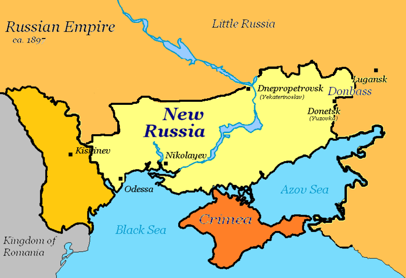
The previous post in this series began to explore the various contexts in which the Molotschna Bullers lived, worked, and worshiped by examining the geography of the area. To summarize the story thus far, the Mennonite colony itself was organized into villages strung along the Molochnaya River and three of its tributaries, seeking to make the best use of both the more fertile river basins and the steppe land rising above the basins. Further, the Molotschna Mennonites had interactions with the various people groups surrounding them: the Muslim Nogai (seminomadic herdsmen) to the south, Russian Orthodox peasants to the north, Lutheran and Catholic German colonists to the northwest, and Russian religious sectarians to the southwest.

All of these groups faced similar challenges and threats to their survival: an undeveloped terrain, a fickle climate, significant distance from ready markets, and overcrowding. How each group addressed these challenges provides us greater insight into what life would have been like for the Bullers and other Mennonite families of the Molotschna colony.

The Socioeconomic Context: Village Life


When Mennonites arrived in the Molotschna region, they intended to live and work on their own independent farms (much like they later did when they came to the U.S.). However, the threat of Cossack and Nogai raids forced these early Mennonite settlers to organize themselves instead into more easily protected villages (see Staples 2000, 239). Therefore, as with most of the people-groups around them, the basic building block, or basic socioeconomic unit, of Mennonite society became the village.

When we say that the village was the basic socioeconomic unit, we should not think in terms of just a village. Rather, the village served as the hub of a agricultural enterprise that extended far beyond the village itself. Thus each village was assigned a specified amount of the more fertile river plains and the higher steppe land surrounding it. A sixth of a village’s land was set aside for population growth (surplus land); the remainder was assigned to those fortunate enough to hold a full land allotment.

For example, the village of Kleefeld was assigned 8,662 acres (ca. 13.5 square miles). The surplus land would have accounted for roughly 1,444 acres, leaving an average of 180 acres for each of the thirty-seven full-allotment holders and 90 acres each for the six half-allotment holders. These land allotments played a key role in the organization and conduct of life within the villages, to which we now turn.

As is evident in the map of Fischau (established 1804) below, these villages were not thrown together haphazardly but were carefully arranged with houses facing one another across a central avenue.


Map © William Schroeder, used by permission. For the original, see http://www.mennonitechurch.ca/programs/archives/holdings/Schroeder_maps/066.pdf

As time went on, it seems that the level of organization extended beyond the macro-level to the micro-level. Thus, when the Mennonite leader Johann Cornies developed a model village for the Nogai in 1835, he specified a precise set of guidelines:

Houses were to be “precisely” aligned along both sides of a single street, “exactly” aligned with the house on the opposite side of the street, “exactly” four sazhens (about 8.5 meters) from neighboring houses, with a surrounding ditch “exactly” two arshins (about 1.4 meters) wide and 1.5 arshins deep, each yard divided into corrals, gardens, threshing yards and courtyards by ditches “exactly” 1.75 arshins wide and 1.25 arshins deep, each with a single gate “exactly” centered on the property, and so on. (Staples 2000, 238)

The same symmetrical and detailed layout is mirrored in the arrangement of Mennonite villages after that time, such as Kleefeld (established 1854), the earliest village to which we can trace our family with certainty.


Map © William Schroeder, used by permission. For the original, see http://www.mennonitechurch.ca/programs/archives/holdings/Schroeder_maps/073.pdf

The holders of full land allotments were at the center of the village, both literally and figuratively. Their houses formed the core of the village, often surrounding a school building, and only holders of full allotments enjoyed the right to vote on village officers and affairs. Villagers who did not own a land allotment lived on the margins (more on them below).

Although it is difficult to determine the dimensions of a typical household plot—that is, house-barn-shed plus corral, garden, threshing yard, and courtyard—it is possible to make an educated guess.
  1. Houses were approximately 28 feet (8.5 m) apart (see Cornies above), so if the houses were roughly 20 feet wide (see the plan below), the entire plot was somewhere around 48 feet wide.
  2. The plot was a little more than three times as long as it was wide, so one can estimate that it was roughly 148 feet long.
  3. Thus, each plot contained approximately 7,104 square feet, which equals .163 acre.
  4. If the dimensions of the plan below are representative, then roughly 33 percent of the entire plot was covered by buildings; the remaining 67 percent provided space for a courtyard, a threshing yard, and a small garden.


Mennonite house-barn-shed floor plan. This particular house-barn-shed was built in Hochfeld, Kansas, but was patterned after the typical Molotschna design. The house is 20' x 42' + one bedroom; the barn and shed are 25' x 62' minus one bedroom. Drawing after Schmidt 1985, 14.                                                                                                                                                                                                                                                                                       
Of course, there was not strict uniformity of plot sizes from village to village or of house sizes within the same village. Further, houses within the same village did not conform to a standard pattern. Some families had house-barns as pictured on the left rather than house-barn-sheds, while others lived in house-barns with a shed to the side to form an L-shape.

Further, villagers who did not own livestock but who earned a living through some other means no doubt lived in houses designed for their particular needs, perhaps with a shop or other work area in place of a barn or even a simple cottage all on its own.

Model of an L-shaped Molotschna colony house constructed by B. B. Neumann (1947).

As a largely self-sustaining socioeconomic unit, the village also provided places for its citizens to conduct day-to-day business, to worship on Sundays, and to gather together in order to decide the questions that faced them as a community.

Thus one might imagine, in addition to the household plots and schoolhouse already mentioned, home-based shops and work areas for blacksmiths, cobblers, woodworkers, tanners, spinners, weavers, tailors, and other artisans, as well as a general store where villagers could buy products that they could not make for themselves. One wonders if villages typically had a market area as well, where villagers could buy, sell, and exchange food items or the products of their own cottage industries. Finally, many Mennonite villages had a separate church building where the community gathered for worship and special events.

As alluded to earlier, the quality of life in the village depended to a great extent on whether or not one owned a full land allotment. The thirty-seven larger rectangles in the Kleefeld map represent the village plots of the thirty-seven Kleefeld residents who owned the rights to a full land allotment of 65 desiatinas (ca. 175 acres). Except for a few exceptions, the smaller rectangles on the two ends of the village represent the 50 percent of the population who did not own the rights to any land.

This half of the village population fell into two categories:

  • The Anwohner owned their own houses. Some of these individuals accumulated significant wealth as traders or store owners, but the majority were not so fortunate.
  • The Einwohner, or cottagers, rented their homes and worked as servants or laborers, whether in the homes of the more well-to-do or in the fields.

According to John Staples, “in 1860, 69 percent of the landless families were Einwohner and 31 percent were Anwohner” (2007). For Kleefeld, then, one might suggest the following demographic breakdown:

holders of full allotments    37 families
holders of half allotments    6 families
Anwohner (house owners)       12 families
Einwohner (renters)    26 families

The socioeconomic stratification could not be clearer: the two largest groups (both of which were larger than the two middle groups combined) were at the two ends of the economic spectrum. Further, because only holders of full allotments had the right to vote, they controlled who could rent the surplus land that belonged to the village as a whole. Not surprisingly, they rented it to members of their own group. As a result, all of the Einwohner and many of the Anwohner eked out a meager living working as laborers for their more wealthy neighbors, with little or no hope of improving their lot in life.

To bring this all home, it seems reasonable to conclude not only that Peter D was landless but that he also was one of the Einwohner. He was, to be sure, related by marriage to a landowner, having married Sarah Siebert, daughter of Johann, who held a full allotment in Kleefeld (see here), and he may have worked on his his father-in-law’s assigned fields. However, the fact that Peter D moved his family twice during the first five years of marriage (Kleefeld to Alexanderkrone to Kleefeld) implies that he probably did not own a house in either village (he was not one of the Anwohner) but rather rented a cottage on the edge of town.

With no hope of inheriting or buying his own land allotment in Moltschna (more on that in the next Bullers in Molotschna post), it is no wonder that Peter D and Sarah (then pregnant with their seventh child) made the decision to seek new opportunity on the Nebraska plains.

Sources

Neumann, B. B. 1947. Grandfather’s Home: Replica of a Mennonite Farmyard in Russia. Mennonite Life 2.1:46.


Schmidt, Richard H. 1985. The Hochfeld Village. Mennonite Life 40.1:12–16.


Staples, John R. 2000. “On Civilizing the Nogais”: Mennonite-Nogai Economic Relations, 1825–1860. Mennonite Quarterly Review 74:229–56. Online here.


———. 2007. Putting “Russia” Back into Russian Mennonite History: The Crimean War, Emanci-pation, and the Molochna Mennonite Landlessness Crisis. Mennonite Life 62.1. Online here.


Tuesday, August 5, 2014

Grandpa and Grandma’s houses

A quick trip down memory lane, all thanks to the wonder of Google Maps and its Street View.

In the late 1950s Grandpa and Grandma moved off of the farm and “into town,” Lushton, that is. Their house in Lushton still stands (although it looks somewhat bare without the sweeping porch), serving today as the place of business for Baladan Jams (photograph taken 2009). The sign does say “Visitors Welcome,” so stop in next time you find yourself in Lushton with nothing else to do!


To explore more of Lushton via Street View, click here and use your mouse to navigate through town.

From Lushton they moved to Friend, where Grandpa built two houses. The first one was located on 6th Street. They lived in this house for only a short time and eventually sold it to my Grandpa and Grandma Meinke. See further on Google Maps here.


Grandpa and Grandma lived much longer in the second house that Grandpa built, pictured below. Many of you will no doubt remember the huge family gatherings for Thanksgiving, Christmas, New Year’s Day, and other holidays. This was a great house in many ways, but what stands out in my mind is Grandpa’s collection of clocks (another Mennonite connection) in the basement area off of the garage.


To explore the area on your own, click here. The lot across the street to the south looks nothing like it did back in the late 1960s and early 1970s.

After Friend came 614 East Avenue in York. My clearest memories of this house involve Grandpa teaching himself “new math” so he could earn his GED and the tight quarters of his shop area in the basement. To explore the area further, click here.


If anyone can supply dates of residence for any of these houses (when Grandpa and Grandma moved in or out), please leave a comment or send an email, so I can update the information here.

Saturday, August 2, 2014

School in Molotschna: Kleefeld

The amount of material available online, including raw historical data in the form of transcriptions of government, church, and secular records, is astounding. For example, this site links to various compilations of data relevant to the Mennonite time in Russia, including school attendance records (scroll down to Molotschna Colony > School Registers).

A typical Molotschna school building. In some villages the school met in the same building as the church.
From: http://www.hdremple.com. 

Clicking on the link for the 1857–1858 school registers leads to a page listing the various villages for which records are available for that school year—including Kleefeld. If you recall, Kleefeld is the village where Peter D and family lived before and after living in Alexanderkrone (where Peter P was born in 1869) and from where they emigrated to the U.S. in 1879.

Unfortunately, no Bullers are listed in the Kleefeld school register, which leads one to wonder when David or his son Peter D moved to Kleefeld after the village was established in 1854. I continue to think that Peter D was probably the first of our line to live in Kleefeld, sometime after his marriage to Sarah Siebert in 1866 (more on that below). That would explain the lack of Bullers in the 1857–1858 school register, as well as the fact that David is reported to have died in Waldheim, a village in the northern part of the colony.

But back to the records: to examine the data for yourself, click here. The register lists the students in order of their family’s Wirtschaft (land-holding), that is, in the order in which land was allotted to the founders of the village. Thus one finds Klaas Kroeker’s two kids listed first because Kroeker was the holder of the second Wirtschaft in Kleefeld (see here for the land allotments; presumably the holder of the first Wirtschaft had no school-age children), followed by the children of Michael Plett, holder of the third Wirtschaft.

Of course, this means that the landed families are listed first (kids 1–63), followed by the landless families (kids 64–84). Stated differently, 75 percent of the students came from landed families, 25 percent from landless families. Since we know that most families in the Molotschna colony were landless by this time, one wonders if their children were less likely to attend school.

Copying and pasting the data from the school register into an Excel worksheet, then sorting it in various ways, leads to a number of additional observations about the Kleefeld student body of 1857–1858.
  1. The register lists 84 students and gives the ages for 77 of them. Students ranged from six years old to thirteen. This is consistent with the practice in other villages, which offered grades 1 to 7 or 8.

  2. Whether through chance or design, the younger classes were larger than the older ones, with the classes of six- and nine-year-olds including 13 each and the class of twelve-year-olds having only 4 and the thirteen-year-olds only 6. 

  3. In terms of gender, the student body was evenly divided, with 42 girls and 42 boys. However, one observes a shift in gender balance from the younger to the older grades. Girls are clearly in the majority in the first four grades (28 girls to 18 boys) but in the minority in the last four grades (11 to 20). This may be due to nothing more than random distribution, but it raises the question whether a girl’s responsibilities shifted from school to elsewhere (e.g., helping with young children in the home) earlier than a boy’s responsibilities shifted.

  4. Some kids have comments accompanying their records. Thus six-year-old Peter Quiring will forever be known as “not capable.” More interesting are the notations of children who either moved to or away from Kleefeld during the year (or for whom a first day of school is listed): 11 of the 84 kids moved in or out during the year, that is, 13 percent of the student body.
    Not surprisingly, all but one of the kids who moved during the school year came from a landless family. What is surprising is that nearly half of the kids from landless families (10/21) moved during the middle of this single school year. This reflects a level of transience that one might not have expected from mid-nineteenth-century villagers. It also may put into perspective Peter D’s later moves from Kleefeld to Alexanderkrone to Kleefeld within the space of four years.

  5. The 84 students of Kleefeld school came from 41 different families. Contrary to common notions of Mennonite family size, most came from families of three or fewer school-age children: 15 kids are the only member of their immediate family in school; 14 are from two-member families; 10 are from three-member families; one family has 5 children in school at the same time (ages six to eleven), and one has 6 kids (six to twelve). 

  6. The age difference between kids from the same family is nearly four years for two-member families and nearly two years between each child of the three-member families. This range is comparable to what one sees in the Peter D generation of Bullers, where kids are generally two or three years apart, although sometimes only a year separates kids.

  7. The most noticeable difference between the Kleefeld data and Buller records is in the size of the families. Only 2 of the 44 families had more than three children in school at any one time, whereas the Bullers of Peter D’s generation averaged 8.8 kids who lived to school age per family. Granted, not all of those kids would have been in school at the same time; however, more than two or three of them would have been school age (six to thirteen) at the same time. Did our Buller ancestors generally have larger families than their neighbors? Did only certain kids from a family attend school? (I see no evidence for that.)
By the way, the Kleefeld school register offers one final piece of interesting information. Student 49 is one Sarah Siebert, ten-year-old daughter of Johann Siebert. We will never know for certain, but it seems probable that this is the Sarah Siebert who nine years later married Peter D Buller. Sarah was born 22 August 1847, which would have made her ten during the 1857–1858 school year, and one online genealogical website lists her father as Johann (see here).

So, it appears that one of our forebears can be documented as living in Kleefeld, and perhaps this also explains why Peter D ultimately called that village home. Although Johann Siebert was not one of the original 1854 founders of Kleefeld, he was owner of a full land allotment by the late 1850s, when Sarah attended school, and presumably continued to hold a land allotment through the 1860s. Perhaps Peter D moved to Kleefeld not only to be close to his wife’s family but also to work on his father-in-law’s farm and thereby provide for his own family.

******

The Bullers in Molotschna series will continue as soon as possible. Hope you didn’t mind this detour in the meantime!


Friday, August 1, 2014

Peter D’s Henderson farm

While work progresson on the next Bullers in Molotschna post, I hope this revised version of an addition to the Buller Family Record will suffice for the moment.

********************************************

Aunt’s Maria and Sara write in the Buller Family Record:

Our dad, Peter P Buller, was born in Alexanderkrone, Ukraine, South Russia, on April 16, 1869. When he was two years old his parents moved back to Kleefeld, where they had lived before. In May 1879 they moved to the United States of America, arriving here in the latter part of June. As for food for their long journey, they packed toasted bread, ham, and coffee, They left Kleefeld, Russia, by wagon to Hochstadt, from there by train across Germany to Antwerpen, Belgium, then on the ship Vaterland of the Red Star Line. They went along the Schelde River to the North Sea, then through the English Channel and across the Atlantic Ocean and landed in Philadelphia, Pennsylvania, from there on train to York, Nebraska. That was as far as the railroad went at that time.

Mr. John Goertzen met them at the station in York (Mrs. Goertzen was a cousin to Grandmother Buller, a sister to Cornelius Quiring, father of our brother-in-law, Dietrich C. Quiring). Mr. Goertzen had come with team and wagon, so they finished their journey the way they had started, namely, by wagon.

The grandparents and their six children stayed with the Goertzens for about a week. During this time grandfather bought an 80-acre farm about 1¼ mile west from where Henderson now is. Dad grew to manhood on this farm.

In the summer of 1887 Dad helped build the railroad west of where the town of Henderson was to be started in the fall.

On January 12, 1888, the grandparents were in Henderson, and the depot agent came to the store and told the people to hurry home, for he had word that a big snowstorm was on the way. They hurried home and were able to get all their cattle into the barn before the storm arrived. It had started to snow the night before and had kept it up all day until in the afternoon. It had been a mild day, snow soft and fluffy at least 12 inches deep. There had been no wind during the snowfall, but at 3 o’clock in the afternoon the wind started from the northwest and a terrible blizzard took place. Many people were caught away from shelter and froze to death. Many of these were school children. The next day the temperature dropped down to 40° below zero.

This short account is packed with information, but for now we focus on the middle paragraph: Peter D’s purchase of a farm. Using historical records not available to Maria and Sara, it is possible to describe the location of the original Peter D Buller farm a bit more precisely than “about 1¼ mile west from where Henderson now is.” We begin with a map of the initial Mennonite family land-holdings, which were located in eastern Hamilton County (Farmers Valley Township) and western York County (Henderson Township).


Of the first thirty-five Mennonite families to settle in the area in 1874 (Peter D came five years later), thirty-four purchased land from the Burlington and Missouri River Railroad within the first year: twelve in Hamilton County and twenty-two in York County (Unruh 1964, 190–91).

John Unruh adds, “Within the settlement the Mennonite families crowded as close together as the alternating homestead lands permitted. In only two places did the Mennonite-owned land not connect at the corners with lands owned by other Mennonites. Relatives endeavored to select lands close to each other—four family heads purchased one section of land, cast lots to determine which quarter section each would buy, and then built their homes close together near the center of the section” (192).

Eventually, in 1887, the town of Henderson was established in the northeast corner of section 6 of Henderson Township, York County (see arrow).


Maria and Sara report that Peter D bought an 80-acre farm within the first week after arriving in 1879. Based on a 1916 map and an 1893 land grant, one can specify further that Peter D’s 80 acres were located in the northeast corner of section 12 of Farmers Valley Township, Hamilton County.


  1. The 1916 map (above) clearly identifies a 160-acre farm in the northeast corner of section 12 as being owned by Peter Buller. Since Peter D died in 1897, this must refer to Peter P.

  2. As one can see in the 1874 settlement map, section 12 is roughly “1¼ mile west from where Henderson now is.” More important, the land was not owned by any individual as of 1874. In all likelihood, it was owned by the railroad until Peter D purchased it.

  3. According to a January 21, 1893, land grant (below), Peter Buller (which Peter is impossible to determine) was granted ownership of 80 acres in the south half of the northeast quarter of section 12 in township 9 north of range 5 (i.e., Farmers Valley Township).


Courtesy of the U.S. Department of the Interior Bureau of Land Management.
See the original scan here.

Based on the evidence, it seems reasonable to conclude that Peter D Buller purchased the north half of the northeast quarter of section 12 in the Farmers Valley Township in 1879, with the south half coming into the family’s possession in 1893 via a land grant. If the grant was made to Peter D, then presumably Peter P purchased or inherited the entire 160 acres. If the grant was made to Peter P, then one expects that the original 80 acres (north) was passed on to Peter either through purchase or inheritance, in order to keep the family farm intact.

Of course, numerous questions remain:
  • Did Peter D purchase the original 80 acres from the railroad or from a private party?
  • How much did he pay for the original purchase?
  • Did Peter D pay cash or somehow secure a loan in order to make the purchase? Did he receive any funding from the larger Mennonite community?
  • What crops did Peter D raise? What livestock did he keep?
  • How does this all relate to that fact that Peter P moved to the Epp family farm when he married Margaretha in 1890 (see here)? Did he perhaps live on the Epp farm but work both that and the Peter D farm? 
Even if the answers to these and other questions remain fuzzy, one thing we do know is that the original Peter D Buller farm was located in section 12 of the Farmers Valley Township in Hamilton County, that it eventually came to include 160 acres, and that the land was acquired both through purchase and via a homestead land grant.

Source

Unruh, John D., Jr. 1964. The Burlington and Missouri River Railroad Brings the Mennonites to Nebraska, 1873–1878, Part II. Nebraska History 45:177–206. Freely available online here (it is an interesting read).